A picture is worth a thousand words. For us at GBWN, that means imagery from hydrologic models used to justify water grabs are worth a hard look and lengthy discussion.
Now that the Bureau of Land Management is re-starting the environmental review on the dangerous, water-sucking West Desert Water Grab, we are looking at some of the data that Iron County has previously submitted in the record.
What we review below shows that Iron County will impact other people’s water supplies in and outside of Pine Valley. That means farmers, rural communities, a tribal nation, and the natural world could all experience unnecessary degradation if they are allowed to pump billions of gallons of water per year to send to Cedar City for sprawl development. It means that water will be sucked away from other places to benefit another under a ruse that all is well.
Paul Monroe, the water official leading the charge for this project, like to tell journalists and the public that there is nothing to worry about. But his assertions betray his own data.
We are dealing with a groundwater system that is inherently connected. The basins in this region are not separate buckets. They are connected and water from one basin is moving to another. Think of this like putting lots of straws in one cup rather than separate cups.
Models are often used by project proponents and opponents to make their case for why a project is doable or problematic, respectively. Models, which are computer-generated simulations of hydro-geologic conditions, often shine a light on layers of certainty or uncertainty regarding pumping and diverting of aquifers and surface-water systems.
Models can articulate varying degrees of accuracy or likelihood. Ask ten different modelers to make a model of a given system and you will likely get ten different models with differing results. If you are a project proponent, a model can be crafted in a way that justifies the effort.
Nevertheless, when a project proponent says that its project won’t harm existing rights holders or the public interest, you would expect the model to justify the case.
That’s why it’s worth taking a look at the Central Iron County Water District’s model used to justify its West Desert Water Grab, or Pine Valley Water Supply Project.
Officials from the water district say that their project won’t cause any problems in the heart of the Great Basin. But its own model says otherwise.
What the Iron County Water Data Say:
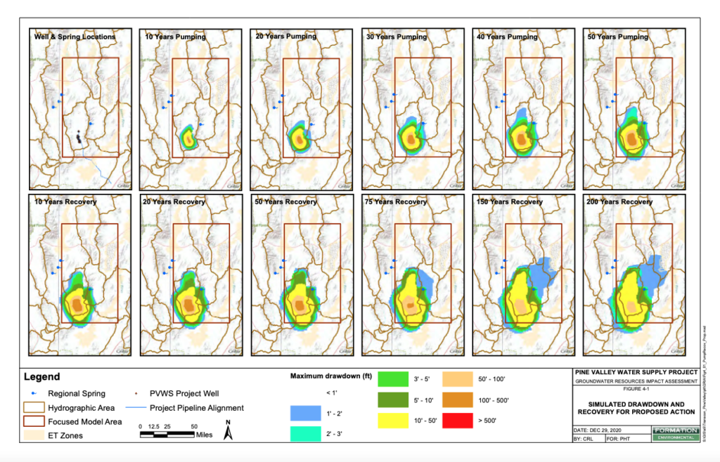
The pumping scenarios above are Iron County’s Water District’s representation of what will happen over time when they pump billions of gallons annually in Pine Valley, just south of Great Basin National Park. Our own analysis of US Geological Survey data demonstrates that the conditions during and following the pumping could be worse.
But the upshot is that Iron County Water officials are demonstrating that its pumping will impact other basins, bringing a likelihood of harm and uncertainty.
Regardless, Iron County’s simulations, conducted by their consultant, also show what happens to aquifers even after pumping stops, listed on the images as “Recovery.”
Recovery is important to consider because aquifers don’t react like brakes on a car. Once pumping ceases the phenomenon underground known as a cone of depression continues to deplete aquifers. So time to recovery implies when, in perfect conditions, aquifers would return to normal.
Again, these impacts will not be confined to the immediate project area. It will be at a regional scale over time.
The scenarios above show hydrographic boundaries of other basins like Snake Valley to the north and west (home of the Park), the Escalante Desert to the South, Wah Wah Valley to the east, and Tule Valley to the northeast. Other deserts are included.
What these images show, according to Iron County Water officials, is that their pumping will impact water supplies greatly in Pine Valley and outside of Pine Valley. There are hundreds of feet of drawdown predicted for Pine Valley and 50 feet of drawdown predicted in basins in the Sevier Desert, Escalante Valley, Wah Wah Valley and in some parts of Snake Valley.
That is not allowable.
In other basins, there is a few feet of drawdown can mean springs go dry or wells go dry. It can mean big costs for water users and wildlife.
Again, these images are from the first round of the federal environmental review that BLM released in early 2022. GBWN, Beaver County, Millard County, Juab County, and White Pine County (NV), along with the Indian Peaks Band of Paiute, all submitted comments. Thousands of individuals signed petitions and submitted comments.
That led to the pause of the review in Spring 2023.
But now with a new administration in DC and a major regulatory shakeup at the Bureau of Land Management, Iron County Water officials believe now is the time to try again. Never mind their interpretations, we know that this project cannot move forward without it triggering problems for communities — human, plant and animal.